Table of Contents
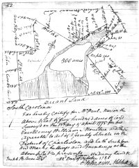
South Carolina state plat, William Paul Marion, 500 acres, District of Charleston SC, 22 Oct 1785
Text
[Includes names of owners of bounding plats:]
[north] Henry Winingham's [sic: Winningham's]
[northwest] Richard Norman's Land
[west] John Hays land
[southwest] John Cook land
[southeast] Vacant Land
[northeast] Surveyed for Peter Oliver
South Carolina
I do hereby Certify for Wm. [William] Paul Marion the above plat of five hundred [500] acres of land Surveyd [sic] on the 13th Day of April 1775 [13 Apr 1775] for his Excellency William Moultrie and Elaps[?] agreeable to act of assembly situate in the District of Charleston and hath such form and marks buttings and Boundings as the above plat represents
Given under my hand this 22d Day of October 1785 [22 Oct 1785]
{signed} Joseph Palmer D.S. [Deputy Surveyor]
{signed} Ephraim Mitchell S.G. [Surveyor General]
Image
Source
- South Carolina Department of Archives and History. Microfilm ST0569. South Carolina state plats: Charleston series, 1784-1860. Series S213190, Reel 2, Volume 4, Page 52.
