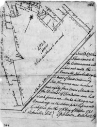
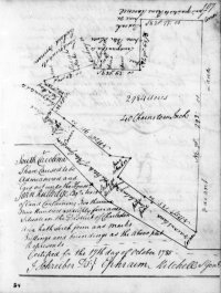
South Carolina state plat, John Rutledge, 2984 acres, District of Charleston, 17 Oct 1785
Text
[Includes names of owners of bounding plats:]
[N] Land granted to Richard Norman
[NNE] Land granted to Peter Oliver
[NE] Land granted to Rene Ravenel
[E & S] vacant Land
[SW] Land belonging to the Estate of Peter Gourdin
[W] John Cooks land
[NW] land granted to John Hay
South Carolina
I have caused to be Admeasured and Laid out unto the Honorable John Rutledge Esqr a tract of land Containing Two thousand nine hundred and eighty four [2984] acres Situate in the District of Charleston and hath Such form and Marks buttings and Boundings as the above plat Represents
Certified for the 17th Day of October 1785 [17 Oct 1785]
{signed} J. Schreiber D.S. [Deputy Surveyor]
{signed} Ephraim Mitchell S.G. [Surveyor General]
Images
Sources
- South Carolina Department of Archives and History:
- Microfilm ST0570. South Carolina state plats: Charleston series, 1784-1786. Series S213190, Reel 3, Volume 8, Page 501.
- Microfilm ST0572. South Carolina state plats: Charleston series, 1784-1787. Series S213190, Reel 5, Volume 12, Page 107.

